My Own Private (Time in) Idaho

It was nearly 3:00 p.m. when I pulled into the Sawtooth NRA (National Recreation Area) - North Fork Visitor Center. By this point, I had driven almost 1,000 miles over the course of a day and a half. This was to be my final stop before my arrival in the town of Stanley, another 60 miles north.
I strolled into the center, intending to ask the rangers there for information about stargazing spots and recent bear sightings. There was no one at the front desk. ‘Maybe the ranger is using the restroom or something,’ I thought. I browsed maps and examined the taxidermy animals, which included a wolf, a red fox, and a wolverine - all of which I hoped to encounter (just not up close) during my stay.
Minutes passed, but no rangers emerged. I walked up to the front desk and rang the bell there. Ding. No one came. Ding. Nothing. Ding ding. It was dead quiet. Something was off. I wondered aloud, ‘Are they all off on a rescue or something?’ Ding ding ding. A moment later, a custodian entered the center from outside, carrying trash bags. She looked surprised to see me. Relieved to finally encounter another human being, I smiled at her and asked, “Hello, are the rangers in?” She responded, “The center is closed on Sundays.”
Planning
“Idaho? Why Idaho?” That, along with a scrunched-up face, was the common reaction whenever I told friends and coworkers that I was embarking on a 6-day-long road trip to there and back. Some of them jokingly asked if I was going there just to eat potatoes. I had been wanting to visit Idaho for a while, specifically the Sawtooth National Recreation Area, ever since I read this Guardian article highlighting national parks to visit in order to beat the crowds. I just didn’t expect myself to go for quite some time.
Originally, my college roommate and I spent months planning for a week-long camping trip to Minnesota’s Voyageurs National Park (it’s in the article as well). Unfortunately, we had to delay the trip (we’re currently aiming for next year), and I found myself wondering what to do for that week. I already had PTO approved, and while I could have canceled it to save it for later, there was the fact that I had not taken a proper vacation in over three years. The idea of a solo road trip was enticing. NorCal, perhaps? I had been meaning to do that for a while. However, I wanted to go someplace new for once. I opened that article and scanned through the parks. There it was again. The image of mist lazily hanging over a lake enticed me so. It didn’t take long for me to make a decision.
I departed on September 21, a Saturday morning. Driving to Stanley alone would take 18 hours of driving, so I spent the first night in West Valley City, Utah - 15 minutes or outside Salt Lake City. From there, it took another 6 hours to arrive in Stanley, which lay in the heart of the Sawtooth National Recreation Area. I was to spend three nights there before making my way back home, camping for the final night of my trip in the Cedar Breaks National Monument in southern Utah. All in all, I would be driving close to 2,100 miles.
Day One: Arrival
You would think that I looked up the hours of operation for the center when I was planning; I didn’t. Luckily, the custodian was kind and answered my questions as well as she could. For stargazing, she reminded me to check the forecast to confirm clear skies, and she told me about a ranger station just outside of Stanley that could provide additional details. She also told me to drive carefully in the dark since big animals like elk and deer frequently crossed the roads. As for bear sightings, she said one had recently rummaged through the trash bins at the center, and she recommended buying bear spray in Stanley. I thanked her and returned to my car, resuming my drive on Highway 75.


As I drove further into the Sawtooth National Recreation Area, I pulled over several times to breathe in the rich air and snap a few photographs of my surroundings. I had chosen to leave behind my DSLR and wide lens at home (primarily because I had bought a lighter and more compact camera), and I rued this decision throughout my entire stay, frequently using the panorama function on my smartphone’s camera.


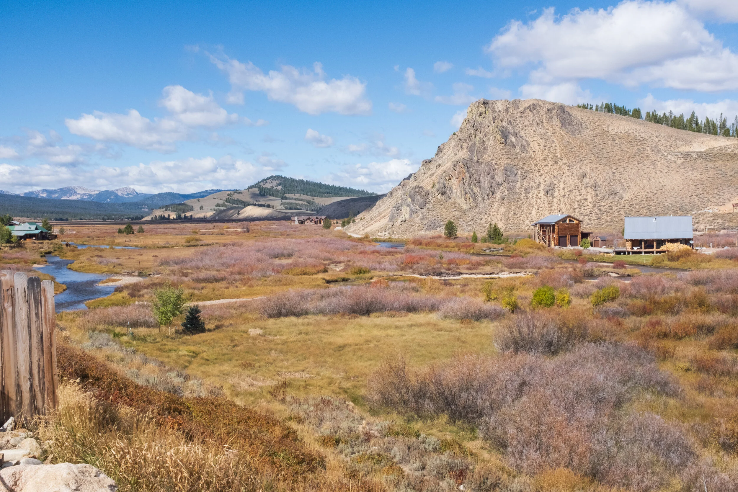
From the center, it took me roughly an hour to reach Stanley, a town with a population of less than a hundred people - 63, according to the U.S. Census Bureau. Prior to my arrival, I knew Stanley was small, but I was amazed at how people could walk to just about anywhere in this town.


I checked into my cabin at Triangle C Cabins, unpacked, and then walked down Highway 21 (AKA Eva Falls Avenue) toward Mountain Village Merc, a local convenience store, located close to where Highway 21 meets Highway 75. I perused the aisles looking for bear spray but found none. I asked the employees whether they had any in stock, but they had none. One of them did say that bears were more common in the Yellowstone National Park parts of Idaho, and that locals rarely worried about them. He could tell that I didn’t look convinced, so he pointed me in the direction of Riverware, an outdoor sports store, across the street, saying that perhaps they had some.

Walking into Riverware, I was reminded of Big Five Sporting Goods. Riverware isn’t as big, but as far as outdoor gear goes, they were well stocked. An employee pulled out their last canister of bear spray for me, and I couldn’t help but pause at the price, which would set me back over $40. I meekly asked if she thought that the spray was absolutely necessary, as I would be hiking the next day. She said no, as bears tend to leave people alone and it had been ages since she last saw one. ‘That makes two locals who said the same thing. I suppose I’ll follow their advice,’ I thought. So I left without the bear spray, confident that my chances of running into a bear were slim at best.
Before I stepped back into my cabin, I stopped by the Triangle C Cabins office to get some must-visit restaurant recommendations in or around town. Amy (I have no idea whether I spelled any names correctly in this post, so I apologize if I did misspell any), one of the proprietors, had several to share: Papa Brunee’s Pizza & Subs, the Stanley Baking Company, and the Redfish Lake Lodge. I also asked her for suggestions on what I could do during my stay, and we chatted for a bit about my trip before I bid her good night. There was still light out, but I had a long day ahead of me, and I needed my rest after a long drive. After preparing a dinner of rice, Spam, eggs, and dried seaweed (a college classic, minus the typically requisite kimchi), I deliberated over gear to pack for my hike and set an alarm for 5:30 a.m. before calling it a night.
Day Two: Attempting the Pettit and Toxaway Lakes Loop
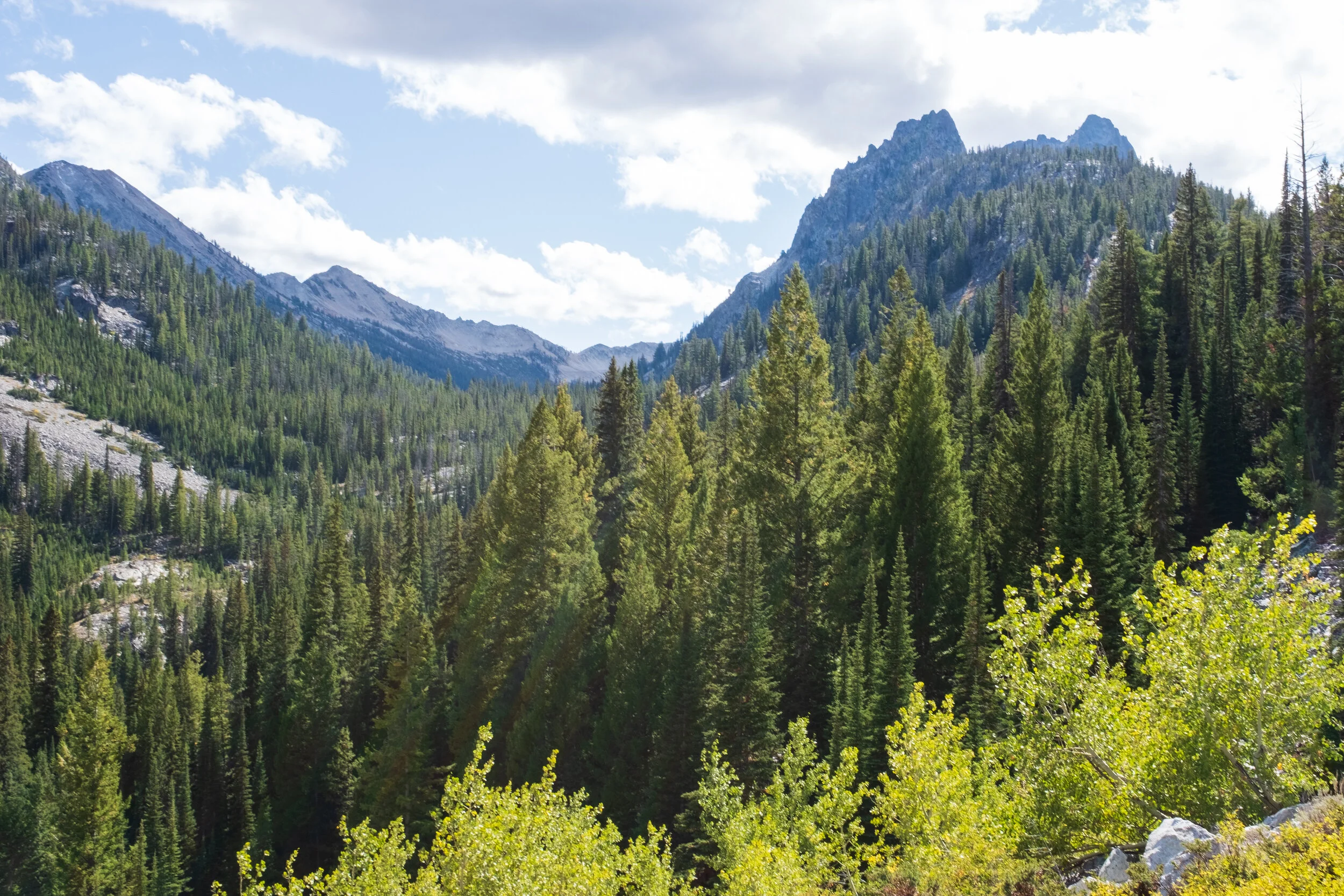
There are so many hikes in the Sawtooth National Recreation Area to choose from, and what makes this task difficult is that you’ll find rave reviews about most of them. There are so many accounts of breathtaking sights as well as exhausting yet rewarding experiences. Should I hike to Sawtooth Lake, as I could also see Alpine Lake? Or should I hike up to Bench Lakes instead? Of all my trip planning, making a decision about this took the longest, as I read as much information as I could about these hikes. Eventually, a few days before I left, I settled on the Pettit and Toxaway Lakes Loop. It is nearly 18 miles in total, features an elevation gain of over 3,000 feet, spotlights several lakes (including Alice Lake - the one that many people raved about) and offers new sights throughout (which is why I tend to prefer loops over out-and-backs). Daunting? Of course. Worth trying? Without a doubt.
My alarm didn’t ring for long before I rose out of bed and started getting ready. I was ready to head out shortly before 6:00 a.m. However, when I opened the door leading out of my cabin, I was greeted by darkness as well as piercing cold. I quickly closed the door and checked the temperature. It was 29 degrees Fahrenheit. I had expected low temperatures, but not like this. A quick Google search showed that sunrise in Stanley was around 7:00 a.m. I decided to err on the side of caution and leave later. I double-checked my gear and ate a light breakfast. An hour later, as light was beginning to illuminate the outdoors, I was in my car, heading south on Highway 75. My destination was the Tin Cup Hiker Trailhead, located 20 miles south. An antelope began crossing the road ahead of me, and I would have hit it had I not slammed on my brakes and stopped just mere feet away from it. I pulled over to see several more cross as well before driving on.
The Tin Cup Hiker Trailhead is located at the far end of the Pettit Lake Campground. Upon arrival, I saw a few tents and one person up and about. The trail, however, was clear, and it would be several hours before I saw another soul. The time was 7:45 a.m. At this point, the temperature had risen to 34 degrees. It was certainly cold when I started the hike, but minutes later, my blood was flowing and the cold not as biting.


Pettit Lake at this hour was nothing short of entrancing. I looked to the east and saw the sun just peeking over the darkened trees, just barely illuminating the environment, as mist slowly billowed over the surface of the water. I looked southwest, where the mountains, bathed in sunlight, reflected almost perfectly in the near-still water. I stepped off the trail to get close to the lake’s shores, where I could see several feet into the water. I made very slow progress on the hike, as I kept stopping every few feet to take photos. Lulled by the incredible sights around me, I moved what felt like a quarter of a mile in 30 minutes.

Eventually, I checked the time and then sheepishly continued my hike, partly annoyed at myself for delaying, well, myself. I had, after all, already chosen to start the hike over an hour later than planned, and here I was, barely making a dent in it. At this rate, I wouldn’t be able to finish the hike until 4:00 or 5:00 p.m. As I crouched and squeezed myself under a fallen tree that blocked the path, I made a mental note to not take as many photos. Not even a minute had passed when I realized that one of my gloves was missing. I had taken it off and stuffed it in my sweater pocket so I could easily take photos, and it must have fallen out. I backtracked about a hundred feet, but there was no trace of it. Knowing I was losing time, I decided to press on. Whenever my hand got cold, I placed it in my sweater pocket to warm it.

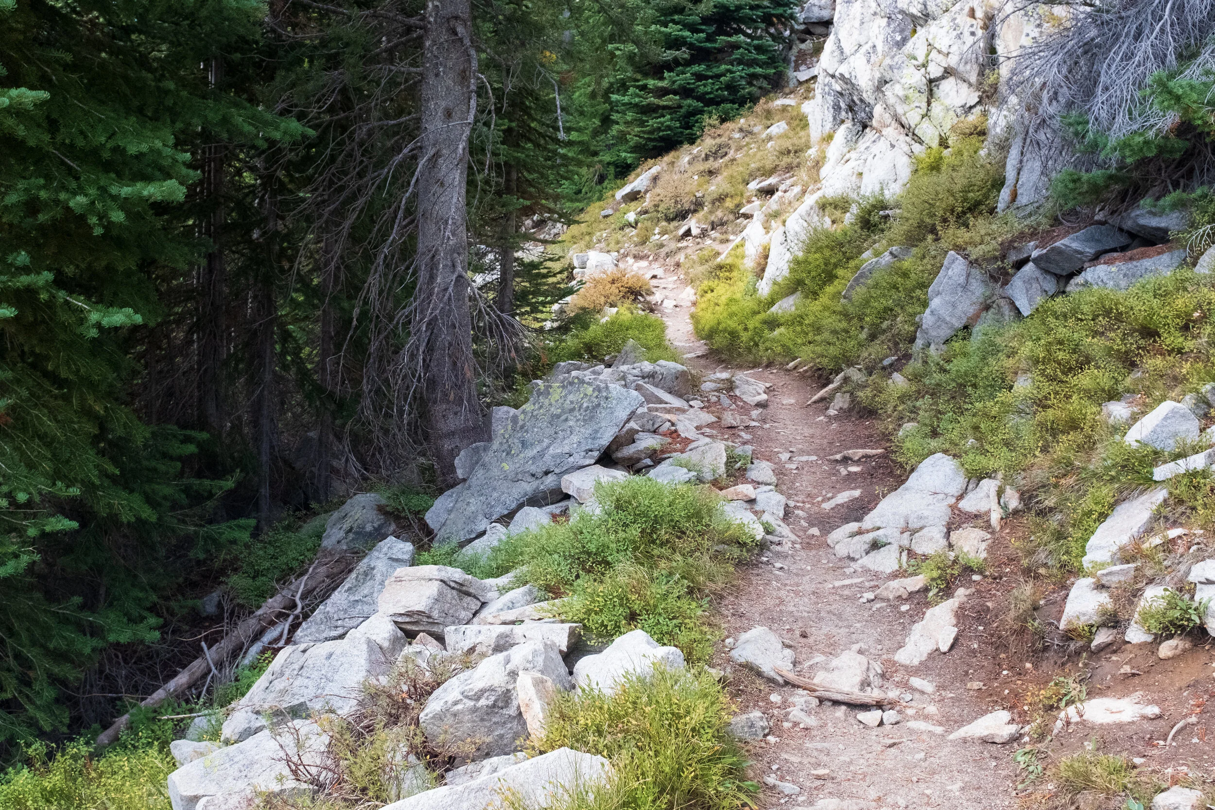
About a mile or so from the trailhead, I came across a marker indicating that I was entering the Sawtooth Wilderness. Right behind it was a box containing wilderness permits, which are required for wilderness use such as backpacking or hiking. I filled out the relevant information (trip begin date, trip end date, number of people in party, expected destinations, number of nights, etc.) and dropped off the now filled out permit into the box’s slot. I attached the tag copy to my backpack, and into the wilderness I went.


The morning sun’s blinding light illuminated the woods, and I was thankful for the shadows that the trees cast on the trail. The trail’s conditions, at first dry and fair, began to vary the further I trekked. It soon became damp - evidence that spring water was nearby. Sure enough, I heard the distinct sound of water running, and upon investigation, I found a very small stream. It wasn’t long before I came across a crudely constructed yet sturdy bridge. It was the first of many on this hike, often taking hikers over mud, water, and unstable terrain. The trail changed again another half mile in, as large rocks started appearing. Some time later, I heard the sounds of water roaring just ahead. This was encouraging, as I had brought only a full Hydro Flask as my water source as well as a Sawyer water filtration system. Pettit Lake was a ways behind me, and having plentiful water nearby ensured I wouldn’t dehydrate. As these sounds got louder, the trees ahead gave way to a small canyon, and below I saw a large stream crashing against rocks as it ran down the mountain.


Every now and then, I glanced at my phone to discern how far I had come using the AllTrails app. Being a paid AllTrails user has its perks, in particular the ability to download offline trail maps. Despite having no Internet access out in the wilderness, my phone’s GPS was working like a charm, showing me where I was on the map. Eventually I decided to check the map only if I felt I was lost, shifting my attention to what was in front of and around me. By now, the woods brightened considerably under the sun, and the wildlife came alive - though I didn’t spot any animals, I could hear them chatter, chirp, and rustle through the brush. Rocks increasingly littered the path in front of me, and I had to be careful on this part of the trail lest I slip and roll my ankle. I briefly stopped to inspect a fallen tree, which had an unusual-looking chunk taken out of it - could it be the work of an American beaver? It was then that I noticed just how many fallen trees were around me. The ones that were perfectly cut were clearly done by saw-wielding woodsmen, but others like the one before me? I got excited at the prospect of seeing a beaver out here and kept an eye out for movement as I soldiered on. The woods opened up, revealing the face of a mountain towering several hundred feet above me, with clear blue sky serving as its backdrop.


I was almost two miles in when the trail was interrupted by a stream. I knew this was coming based on the hike reviews I read on AllTrails, and thankfully, the stream was only a few inches high. Still, I made it a point to carefully cross by stepping on rocks that broke the water’s surface. After I crossed and continued on the path, the woods swallowed me up. Moments later, I noted how ominous this neck of the woods was, especially with bunches of trees had lost their leaves and just stood bare. Some had fallen, creating a wild mess on the forest floor or at times blocking the trail. I felt relief when the brush became greener and thicker again. Not long after, I came across another stream crossing, but the presence of a pile of fallen trees that limited the water flow caught my eye. Was I looking at a beaver dam? I crossed the stream and slightly circled back away from the trail to investigate. The pile certainly was acting like a dam, what with the substantial body of water behind it, but I couldn’t determine whether it was made by beavers. I snapped a few photos (mainly of the mountain being reflected in the water) when movement caught my eye on the trail. A woman and her dog were traveling in the same direction I had been. This was the first person I encountered on the trail that morning. I raised my hand in greeting, and she responded “Good morning” before continuing on her way. I couldn’t help but envy how quickly they were moving, so I returned to the trail and moved on.


As I hiked uphill and admired the vegetation’s slowly changing colors, it dawned on me that the trail had led me into a valley, sandwiching me between two mountains. I craned my neck to spot their peaks and felt very small in comparison. By now, it wasn’t as cold, so I unzipped my sweater and sighed in relief as cool mountain air swept through my shirt, damp with sweat. As I kept moving, the trail got rocky again and took me on a few switchbacks, and it was here that I realized the hike was taking a toll on my body. I was admittedly out of shape, and the trail’s incline was doing me no favors. I paused every now and then to take a breather and admire the view all around me.

The higher the trail took me, the more astounding the scenery became. The panorama function on my smartphone became a very valuable asset. [As I write this, I have found that Squarespace cannot upload some of my really wide panorama shots since it cannot process them properly. It doesn’t help that they are large files. Pity.]


Over a half hour of uphill hiking later, the trail had led me to another stream. Crossing this one was easy, but I had to pause because at first glance, the trail seemed to continue up a series of large rocks. Something about it felt off, so I opened AllTrails to see where the trail is supposed to lead me. Sure enough, I had to take a immediate right after crossing the stream instead of going straight. I climbed over a couple rocks and found the trail, which, while still going at an incline, wasn’t as severe compared to what I had just done. It also led me back into the woods, and I welcomed the shade after being in the sun for a while. After walking for a few minutes, a pair of hikers appeared just ahead of me, heading in the opposite direction. I asked them if they were returning from Alice Lake. They affirmed, saying that it was about a mile or two away. This encouraged me, and we continued on our way. Little did I know what awaited me following another (easy) stream crossing.


The trail again turned to rocks and switchbacks, but this time, the incline was punishing. It didn’t take long before my body told me to stop and take a break. I sat on a nearby rock, removed my backpack, drank water, and took deep breaths before getting back up and moving on. This became a regular routine during the next grueling fifteen minutes or so. I was also hearing what seemed like a combination of chirps and clicks coming from the brush around me, along with the rustling of movement. Whenever these sounds felt close, I rapped my trekking pole against a nearby rock or tree. At the time, I didn’t know what exactly was making these sounds, but I knew it was an animal, and I sure hoped it wasn’t a curious or stalking predator that I couldn’t see. Eventually, I heard the roar of nearby water, and I quickened my pace to find another large stream, with a bridge placed over it on the rocks to continue the trail. As I stood on the bridge, the water’s sounds calmed me down.


The woods appeared again, and as I progressed, I noted that the trail was beginning to flatten. I came across another bridge, which I thought was unnecessary since the terrain under it was manageable, even though it made for solid aesthetic. It didn’t hit me until much later that in the spring, water from melting snow would most likely form springs that ran under the bridge. I encountered the woman and the dog from earlier, who were now heading back. “Are you coming from Alice Lake?” I asked. “Yes, it’s beautiful!” she replied. “I can’t wait to see it!” I exclaimed as we passed by each other. Heart beating quickly with anticipation, I stepped up my pace. Soon, the trees ahead of me parted ever so slightly, and then I saw it.


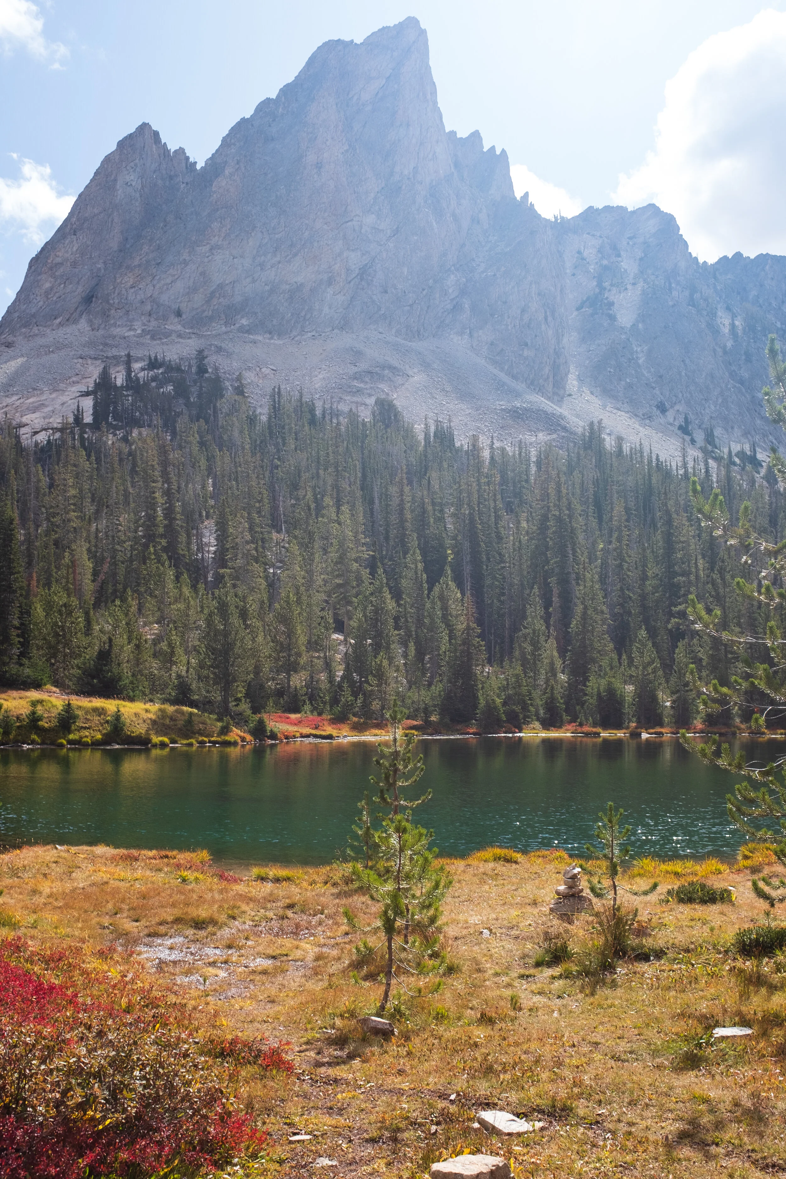
What I saw before me was magnificent. An alluring lake with a small island in its center, surrounded by a congregation of trees, with the mountain that is El Capitan looming over it. The colors on display here took my breath away - a brilliant symphony of blue and green, with hints of red. It was like something out of a fairy tale. The tranquility gave me a fleeting impression that I was the first to discover this. ‘She was right,’ I thought. ‘Alice Lake is beautiful.’ I soaked in the view for a few minutes before I realized something: this lake was small; Alice Lake is much larger. I pulled out the AllTrails app and found out that I was not looking at Alice Lake, which was actually just a little further ahead. Instead, this was one of two lakes that received water from Alice Lake. They are unnamed, but I presumed they were considered part of Alice Lake. Thus, I resumed walking on the trail. Indeed, I saw where water from the other lake (which I’ll call Lake 1) was spilling into this one (henceforth called Lake 2). Curiosity piqued, I wondered what Lake 1 looked like.


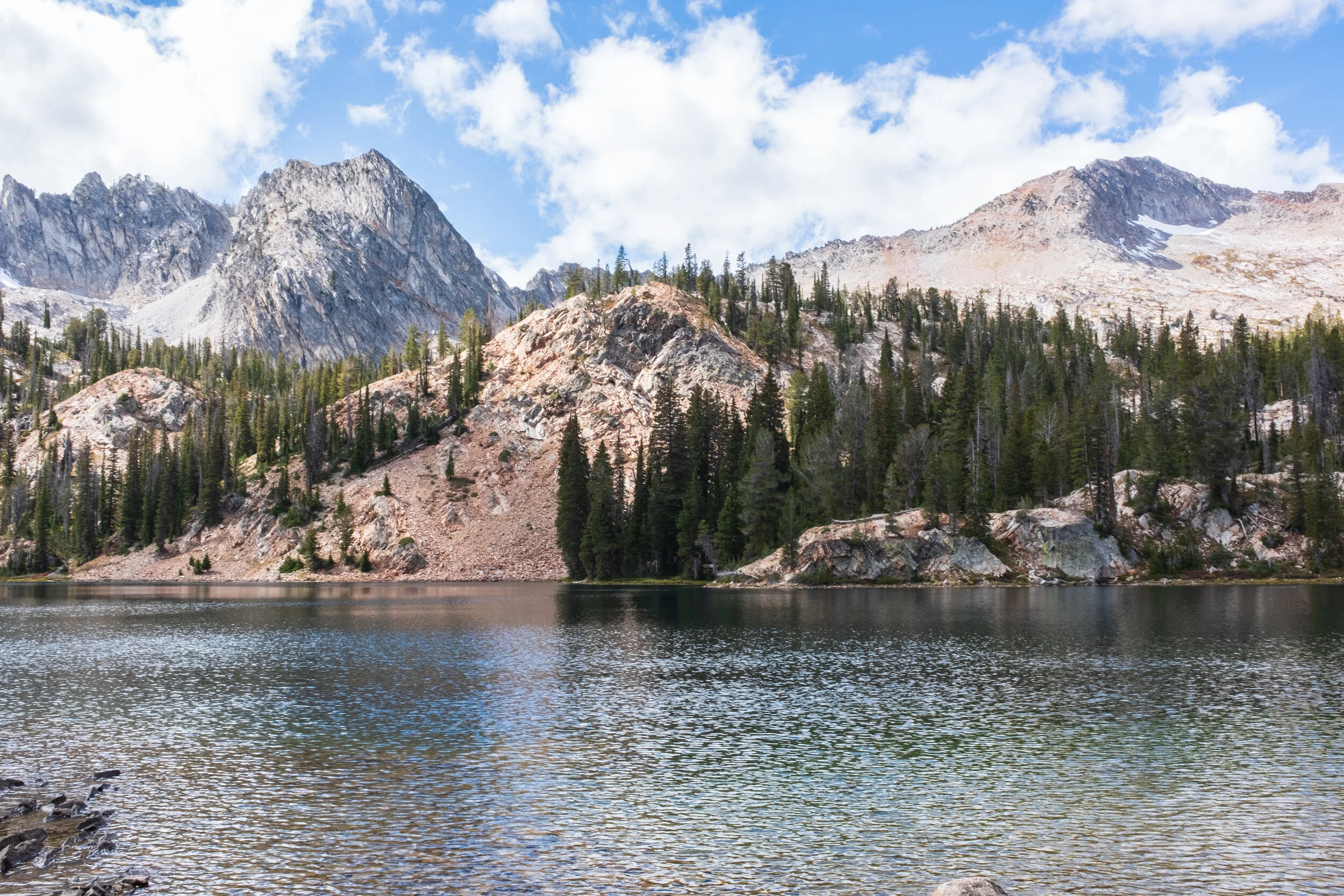
Lake 1 wasn’t the knockout that Lake 2 was, but it was still very nice to look at. It doesn’t have an island, but its waters bore that same lovely green-blue color. It did present an incredible view when taking in its surroundings, as it was closer to El Capitan and I saw more of the red foliage here, making for some nice photos of early autumn here in the Sawtooth Wilderness. That “first to discover this” impression disappeared once I saw a cairn, which you may often see next to lakes and rivers - evidence that countless others have come before me and enjoyed the same views that I did. Not that I minded, of course. The red foliage very much fascinated me, and I couldn’t help but take some close-up shots of it. Back when I first read that article and entertained the thought of coming to the Sawtooth National Recreation Area, I figured that spring would have been a good time to visit. Based on what I saw before me, I was glad that I chose to come during autumn instead. I pressed on, excited to finally see Alice Lake.


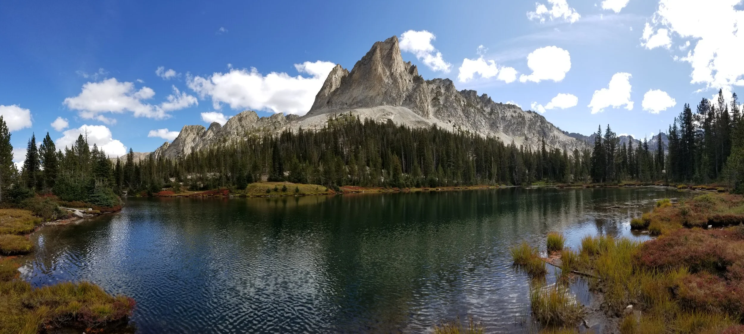
I won’t lie: at first glance, Alice Lake felt underwhelming; despite its impressive scale, it didn’t fill me with the sense of wonder that Lake 2 did. Had this been the first lake to meet my eyes after a long hike, then I probably would have been blown away. I stood still on the trail for a good moment, taking in the view before continuing on, walking along a shoreline of rocks. By now, it was past 12:00 p.m. I had been hiking for over four hours, and not only were my legs aching, I was hungry. I decided to stop and rest for a half hour. Just ahead of me was a tree offering shade, with one of its great roots looking like a nice place to sit. I dropped off my gear and was ready to take my sweater off, but the winds here were blowing pretty hard, so it remained on. I finished the water in my Hydro Flask, so I pulled out the filtration system and read the instructions before heading to the lake’s edge. I filled the pouch with cold, clear water and drank through the straw. It was the best water I ever drank, and I greedily gulped down as much as I could. I filled the pouch again so I could fill up my Hydro Flask, and even after I was finished, I filled the pouch again. I returned to my gear, sat down, and ate my lunch. I chewed slowly, wondering what about being in the great outdoors makes food taste better. A hiker passed by, and we each raised our hands in greeting, exchanging no words - proper, considering just how peaceful it was up here. As far as I could tell, there was no one else here. Stomach full, hydrated, and somewhat rested, I put the remaining food in my backpack, ready to move on - when disaster struck. One of the zipper sliders on my backpack got stuck, and upon giving it a big tug, it came completely off one set of the teeth. Normally, I wouldn’t have been worried as there was another slider, but it too had come off the same set of teeth the night before when I was packing. My backpack’s front compartment was now hanging open. I took the string off my necklace compass and tied the slider to the carrying handle. While it was still open, it was secured - for now. I assessed my situation. Alice Lake was almost six miles into the hike, which left me with another eleven or twelve miles that I had to finish in about five hours before it could get cold and dark. According to the AllTrails map, the next mile and a half consisted entirely of elevation gain. My legs were still aching, and the thought of going uphill for who knows how long made my feet feel heavier. I accepted that given my progress so far, I would be finishing the hike well after sunset. Not enthused by that prospect, I threw in the towel; I would be heading back. My attempt to hike the Pettit and Toxaway Lakes Loop had ended in failure.


I didn’t want to leave just yet, and I knew that returning to Pettit Lake would take less time since I would be heading downhill. Plus, I wanted to take my mind off the disappointment I was feeling at not being able to complete this hike. I decided to explore Alice Lake, continuing my hike just a bit further. The shore of rocks ended, with vegetation taking its place. The trail moved away from the lake, so I went off of it and stepped into the brush, preferring to walk on the lake’s shores. I’m glad I did, as doing so was what revealed the lake’s immense beauty. I climbed a large rock, and I was treated to a stunning view. Moving on, I encountered a few clearings that, from looking at it, had been the sites for backpacking campers. I carefully navigated my way, careful not to slip on mud or wet stones, letting the shores guide me.


As I looked off to Alice Lake’s southwest, I saw what looked like an island. Luckily, it was fairly close to the lake’s, so I headed there. As I got closer, it became clear that it was indeed an island, and a beautiful one at that. As I stood across from it, I wished that I had brought swim trunks so I could swim across to it. I was, after all, about fifteen or twenty feet away. Of course, I remembered the lake’s cold waters, which discouraged any further thought, but my desire to be on that island, to pitch a tent there, to camp there, to fish there, to look upon the lake from there, to watch the sun rise and set there, to gaze upon the stars from there, to call it my own island, burned. Was this the call of the wild? Calling me to be, as the oft-used phrase goes, “one with nature”? Whatever the answer was, I could only wistfully gaze at this island, which I had fallen in love with in only a short matter of time.


Turning away from that island, I saw before me the rest of Alice Lake, which I couldn’t see on the other side where I had first encountered this great lake. ‘It really is beautiful,' I thought, echoing that woman’s words and dispelling my first impression of the lake. I was no longer bothered by me not being able to complete this week; the views here made it all worth it. It was time for me to leave. I turned around and made my way back to the trail. As I returned to where the shores became rocky, I passed by a hiking couple. We exchanged smiles, and I realized that since it was later in the day, I would most likely run into more people while on the way back.


Since my hike had now become an out-and-back hike, I figured that since the sights while heading back were the same as before, they wouldn’t be worth as much. I was happy to be proven wrong, as I soon found while passing Lake 1. Since I was now looking northeast instead of southwest, I was able to see my surroundings from a new perspective. The clouds, which moved very quickly here due to the winds, would at times temporarily mask the sun, leading to varying degrees of brightness and light as I moved. The colors of Lake 1 seemed to darken, and I found myself stopping several times to admire the views.


As I was heading toward Lake 2, I went to the spot where the waters from Lake 1 were steadily spilling into Lake 2 to take some photos when I noticed something new: the waters of Lake 2 reflecting the skies, the trees, and El Capitan. I walked down the trail, to where the waters were calmer, and sure enough, I could see a very clear reflection of the surroundings. Lake 2 took my breath away again - a mean feat considering how it had already done so the first time I laid eyes on it. After taking some photos, I saw that the hiking couple from moments before was heading back as well. They were an older couple whom I guessed were in their mid-fifties or so. They saw me and asked if I could take a photo of them, which I obliged. The man gratefully offered to do the same for me. After a round of taking photos, we introduced ourselves; their names were Kristen and Mark. I asked them if they were heading back to the trailhead, and they said they were. As they turned to go, I found myself moving after them. As much as I had come to the Sawtooth National Recreation Area for some solitude, at the end of the day, companionship was that much better. I didn’t ask if I could join them (in retrospect, I should have), but they didn’t seem to mind as I tagged along.


I figured we would make some small talk on the way back, but I ended up speaking to Kristen and Mark for almost the whole time. From Maryland, the two worked at U.S. Fish and Wildlife Service - well, Mark used to, as he had retired not long ago. They try to visit national forests and parks a couple times a year. This was Kristen’s first time to the Sawtooth National Forest, but Mark had come a long time ago. They spoke of their adventures together, and I felt slightly embarrassed when I told them that I rarely traveled, having only bit the travel bug just last year. They were surprised to hear I had come to Idaho alone but appreciated the audacity of coming on a solo trip all the way from California. The two had already been in the area for a few days, and they would be leaving the day after tomorrow. They shared recommendations for restaurants around Stanley, with Kristen telling me that I just had to try the sourdough pancakes at the Stanley Baking Company. I asked if they had done other hikes; they said they had hiked to Sawtooth Lake just the day before and had run into a bear. Luckily, it didn’t want to bother them, and I couldn’t help but think back to the bear spray I opted not to buy yesterday. At once, I was grateful to be in their company.
Naturally, I enjoyed the return hike. Mark would pause every now and then and point out various things. When there was mud on the trail, he would look down and identify footprints. He pointed to one. “That’s elk. You can tell from the pointed hooves at the top here.” He indicated another. “Mountain lion. Or some big cat.” At one point, when we were back on the rocky switchbacks, he stopped us and pointed some distance away. “Marmot. Do you see it?” Admittedly, I couldn’t make it out from among what seemed like an infinite amount of rocks. While we were crossing the stream with what I had surmised to be the beaver dam, I slipped and fell into the water. Luckily, I wasn’t hurt, and nothing valuable of mine was wet. I considered myself lucky; earlier at another stream, Mark said that had we come in the spring, the stream would be coming up to our knees or even our waists due to snow melting. I pointed to the pile of trees. “Hey Mark, is that a beaver dam?” He took one look at it and said no; so much for my observation and theory. My glove was wet from my fall, so I took it off. He saw it and said, “Say, we saw a glove just like that [near Pettit Lake]!” My lost glove! I told them about how I had lost it, and they said that there was a good chance we would run into it again.
We only paused a handful of times on the return hike, and I could tell right away that Kristen and Mark were experienced hikers. We were hiking at a consistent pace, and by the time we were about two miles away from the trailhead, my feet were begging me to stop. However, I didn’t want to ask them to slow down, so I gritted my teeth and forced myself to endure. As we passed the Sawtooth Wilderness marker, I was going slower than they were but was determined to somewhat keep up, keeping several paces behind them. I mentally yelled with joy when Pettit Lake came into view; it would be over soon. Kristen and Mark rediscovered my glove, which someone had put on a stick that they had stuck into the ground just next to the trail. We laughed at the sight, and at 4:30 p.m., we arrived at our cars in the trailhead parking lot. I dropped my backpack in the trunk of mine and collapsed into the rear seat, sighing in utter relief and drinking from a large jug of water. My shoulders and pretty much the entire half of my body were aching. Mark shot me a grin when he saw me half-collapsed in my car seat. I remained there for a good ten minutes, glugging down water and taking deep breaths, getting up only to bid my newfound companions farewell when they departed. Wanting nothing more than a shower, I left soon after.


On the way to Highway 75, I noticed a herd of animals in the fields some distance away, and I stopped to take a look. Even when I zoomed in on them with my phone’s camera, I couldn’t identify what they were, but either deer or antelope were my best guesses. Perhaps they were the elk that Mark spoke about. I stared at them until they started moving along, prompting me to do the same. When I was nearing Stanley, I saw a car pulled off to the side of the road with its occupants taking photos of something in the fields. This was a cue for me to pull over as well and see what they were looking at. It was a solitary antelope grazing. I wasn’t in a good position, though, so after taking some quick photos, I drove on.


Upon reaching Stanley, I made a quick stop at Mountain Village Merc to buy a few bottles of Gatorade. Once I was back in my cabin, I peeled off my clothes and spent my sweet time in a warm shower. After drying off, I collapsed into my bed and checked my hike recording. In total, I had hiked over 13 miles in under nine hours. I didn’t want to leave that bed, so I spent a long time browsing through all the photos I took that day, watching some television, and surfing the web. I started to get hungry, but I couldn’t make up my mind about what to eat. Nearly an hour later, I decided that pizza and a cold beer at Papa Brunee’s sounded swell, so I got in my car - walking be damned - and drove over. Alas, they had just closed for the day! I cursed at myself over my laziness. I could eat at other restaurants, but nothing seemed enticing enough or was open (the Stanley Baking Company was only open for breakfast and lunch, unfortunately). Not in the mood to make a sandwich, I remade the same meal from last night, sans the seaweed. I didn’t enjoy it, which marked the very first time I had such a reaction to this usually reliable meal. After flipping through the television channels and being disinterested in every single program, I turned in early for the night.
Day Three: Out and About in the Sawtooth National Recreation Area
I intended to sleep for as long as I could, so I had set my alarms for 8:00 a.m. the night before. For better or for worse, my body has a habit of waking up early, and it was no different in spite of the exhaustion, as I woke up shortly after 7:00 a.m. My calves and feet were still sore and seemed to groan in protest as I went about getting ready. I figured I could start my day early, but then again, I didn’t have much planned for today, and I was in no rush. I wasn’t hungry yet, so I sorted my belongings since this would be my last night here in Stanley, and I had to depart early tomorrow morning.

The thought of sourdough pancakes eventually got my stomach growling, so I gingerly stepped out of the cabin to begin walking to the Stanley Baking Company. As I looked around me, the sight of the mountain range behind my cabin stopped me in my tracks. I had yet to see these mountains in the morning, and placed against the backdrop of a very overcast sky, they looked impressive. A road dividing the cabins and the Triangle C Cabins office leads to several homes, and I went down this road to take some photographs.


Wanting to snap more photographs, I crossed Highway 21 so I could capture the sense of being in this town. Aside from a few cars zooming by, all else was quiet, and I wondered how incredible it would be to live in a town like this, to see this kind of view every morning.


To get to the Stanley Baking Company, I turned onto Wall Street and walked straight down. The restaurant was on the right side before the street became Airport Road. I entered into a cozy and absolutely bustling restaurant. I wouldn’t have been surprised had most of the occupants were tourists passing through Stanley. I ordered two sourdough pancakes, eggs, applewood smoked bacon, and some hot chocolate. I sat at the counter, where I had a good view of the kitchen. The hot chocolate came out first, and it was perfect for that chilly morning. I sipped on this until the rest of my order came out, and I felt my jaw drop when I saw how humongous the pancakes were. I poured a generous helping of maple syrup on them and took a bite. Hands down, they were the most delicious pancakes I had ever eaten. [I still stand by this opinion as I write this months later.] I savored every bite of those airy and fluffy pancakes - at least, until I was halfway through the second one. My hunger had led me to order two, and one was definitely enough. I barely finished, and while I had been entertaining the thought of buying a berry scone at the bakery counter, I decided I had eaten enough to hold me over until lunch. Feeling heavier but content, I lumbered out of the restaurant.


I didn’t want to return to the cabin just yet, so I decided to walk around Stanley a bit further. I encountered Stanley Scoops, a local ice cream joint on the corner of Wall Street and Ace of Diamonds Street. However, the sign on the window stated that they were closed until next summer. Summer is tourist season for Stanley, and that tends to be when the town’s population increases. Come summer’s end, though, and it’s common for some businesses to close until tourists come out in droves. [I just found out that the Stanley Baking Company is closed for the rest of the 2019 season until May 2020.] Turning onto Ace of Diamonds Street, I passed by Kasino Club and Papa Brunee’s, making a mental note to come by the latter for dinner later. When the street met Niece Avenue, I saw the Stanley Community Library next to the Stanley Town Square just a ways down. I love visiting libraries, but since it didn’t open until noon, I turned onto Niece Avenue and headed back toward Highway 21. By now, I noticed that the skies had cleared considerably, and the mountain range was worth taking a few more photos of. I returned to Triangle C Cabins and went down that road to do just that.
Back in my cabin, in between packing my belongings and making a lunch to take out later, I thought about what I should do for the day. Stargazing was happening no matter what, but that wouldn’t be until 7:00 p.m. or so. When I had first booked my cabin, Triangle C Cabins would suggest some activities, and rafting on the nearby Salmon River was one of them. The thought of sitting on a raft and eating food while lazily drifting down a river had made me very excited and was a natural choice for a post-hike day. Unfortunately, when I had called ahead to confirm reservation details, I was told that rafting was no longer possible since the water levels in the Salmon River had gone down. I was recommended to visit Redfish Lake, which was about eight miles away. There was, of course, the library and the ranger station that I wanted to visit. After some deliberating, I decided to: visit the Stanley office to get some stargazing recommendations, then the library, then the ranger station, and finally Redfish Lake.


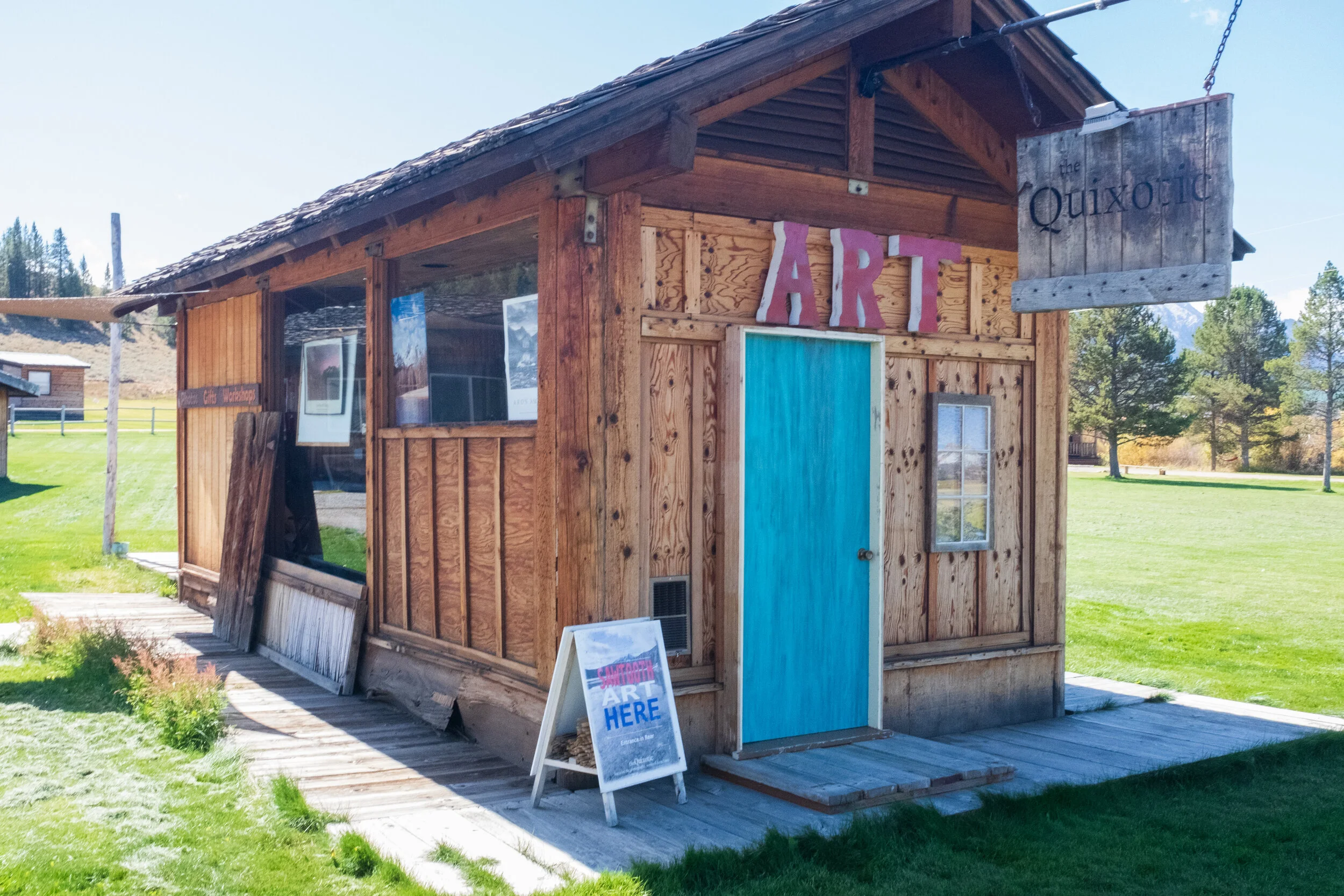
My quest to receive advice for stargazing locations at the Stanley office more or less yielded the same result as my visit to the Sawtooth NRA - North Fork Visitor Center did: the employee there recommended that I go to the ranger station. As I walked to my car, I noticed a lookout over Valley Creek, which diverts some water from the Salmon River through Stanley just north of Highway 21. This would be a good place to sit down and rest, especially during a sunset, when everything would be cast in a golden light. The Stanley Community Library had a solid collection of books, and there were only a handful of patrons. For the next half hour, I made myself comfortable, reading through a copy of the community newspaper and flipping through some familiar books I read in my youth. Later, as I headed toward Highway 75, I pulled over upon seeing what looked like a single-room art gallery. It was indeed a gallery of sorts, called the Quixotic. Unfortunately, it was closed, and a note on the rear entrance gave the phone number for those interested in a showing. ‘Perhaps another time,’ I thought, returning to my car.

The Stanley Ranger Station is located less than four miles south of Stanley. I entered the building and, seeing that the rangers were currently speaking to other tourists, occupied myself with browsing through books and maps. When one was available, I immediately asked her about stargazing locations. In my research, I had whittled my choices down to two sites: the Park Creek Overlook to the west, and Sunny Gulch Campground, which was another two miles south. The ranger recommended the former, saying that the latter would have more people and thus, more chances of fires and flashlights being used. Thanking her, I was about to leave when I inquired about the Salmon River - were there still salmon there? I would love the opportunity to see live salmon. She said that such questions would be best asked at the Sawtooth Hatchery, which was a further four miles or so south from the station. I realized that I had seen plenty of signs for it during my stay here so far, and my curiosity had been piqued. The memory of watching the Magic School Bus episode about salmon back when I was a child suddenly hit me, and I decided, ‘Why not go?’

The Salmon River runs alongside Highway 75 for quite an impressive distance, and on my way to the hatchery, I pulled over upon noticing how seemingly low the river seemed. I distinctly remember the water levels being higher (as well as the river being wider) upriver, and I couldn’t help but wonder where exactly the raft rides would begin. Surely it had to be farther north from Stanley lest the raft rides be too short for people’s liking.


Upon arriving at the hatchery site, I poked my head into a single-room gallery that overlooks an incubation laboratory. There was no one in either the gallery or the laboratory, so I looked through the collection of photographs and read about the history of salmon in the area and the hatchery itself, which is part of the Lower Snake River Compensation Program - a federal program created for fish loss compensation resulting from the construction of the Lower Snake River dams. Salmon (which include the Chinook and sockeye salmon) numbers have steadily decreased over the years, and I couldn’t help but appreciate the hatchery’s efforts. Stepping outside, I spotted several raceways, and upon approaching, found that they contained various salmon and trout fingerling, also known as juvenile fish. If I stepped too close, I could see them dart away from me. Next to the raceways and past a fence were several ponds. One was a fishing pond for children to catch rainbow trout, which I could see just beneath the surface of the water. I walked around the other ponds and saw no fish, but did encounter a dead snake. Satisfied to have seen live salmon, I left the hatchery and drove up to Redfish Lake.


On the northern shores of Redfish Lake is Redfish Lake Lodge, which offers various accommodations to tourists. After parking, I headed straight toward the lodge’s marina. Having read Gary Paulsen’s Hatchet series many times as a child, I had always wanted to travel across lakes and rivers in a canoe as the lead character in the later books did. After speaking with the marina employee on duty named Matt (also from California!), I rented a canoe for two hours, wanting to paddle around the whole lake. ‘How hard can it be?’ I thought. After nearly tipping over three times in the first few minutes, I discovered just how hard it was. First I had to get used to balancing myself, then I struggled to get the canoe to go straight, as I had to alternate my strokes from side to side. Instead of heading south, I kept to the north side of the lake, keeping close to shore. If I got too close to the point where I see the bottom of the lake under its clear waters, I pushed myself into slightly deeper water. After almost tipping over again, I decided to return, not wanting to get myself or my camera gear wet. Every now and then, the winds would blow across the lake, which made balancing more difficult. Matt didn’t seem surprised to see me return after only a half hour on the lake. He asked if I wanted to try a kayak instead, as it was better for balance and featured a double-bladed paddle. I decided to give it a go. Balancing on a kayak was much easier, and I felt more confident in getting the kayak to go straight using this new paddle. After going on the same route as before, I navigated back toward the marina and then in a southerly direction, making sure not to get too close to shore. I managed to get about a half mile or so away before I checked the time and saw that I only had about a half hour left. I decided that going around the lake was a foolhardy endeavor, so I turned around. A boat sped by, and the wake it left behind made the kayak unstable for a moment, requiring me to carefully balance myself. I soon made it back and thanked Matt for helping me out. I came here wanting to fulfill a romantic childhood dream of mine, and I was instead treated to a healthy dose of reality.

On my drive back to my cabin, I once again saw autumn’s colors appearing in the landscape. The sun, high in the sky, bathed it in its bright light, livening these colors even more. I wished I could spend more time in the Sawtooth National Recreation Area, but I only had so much time left. Back in the cabin, I put aside the gear I could need for stargazing later while continuing to pack anything I wouldn’t be using before my departure tomorrow. When the clock passed 5:30 p.m., I headed outside, determined to finally get the pizza and beer I had craved the day before.


There were well over a dozen patrons at Papa Brunee’s when I entered, and I greedily inhaled the wafts of pizza baking in the kitchen before approaching the counter. The Grand Teton Brewing 208 Session Ale seemed like an inspired choice, so I ordered a pint of that. All of the specialty pizzas sounded great, and after some thinking, I went with the personal sized Sawtooth Special, which contained pepperoni, Canadian bacon, Italian sausage, black olives, mushrooms, green peppers, and onions. The ale would have been absolutely perfect for a post-hike drink yesterday, but I wasn’t complaining after a day of going all around town and beyond, relishing every sip. I tucked into the pizza as soon it arrived, and biting into the thick crust - flavored by the melted cheese, sauce, and crisp toppings - made me very happy that I chose to come here for dinner.
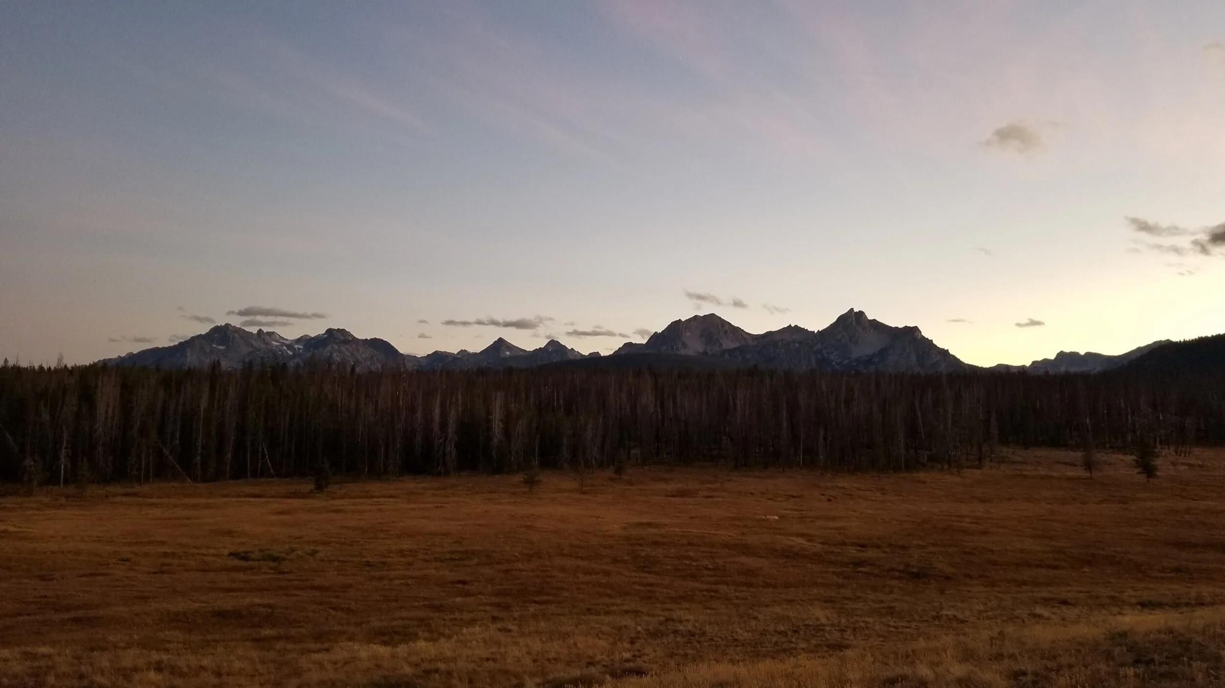
Back when I was researching the Sawtooth National Recreation Area, I came across the term “Central Idaho Dark Sky Reserve” and was intrigued. After researching further, I found myself more excited for this than the lakes and hiking. An International Dark Sky Reserve, certified by the International Dark Sky Association, is a public or private land that offers a remarkable quality of starry nights and nocturnal environment that is protected specifically for scientific, natural, educational, cultural, heritage, and/or public enjoyment purposes. This is one of only 13 certified reserves in the world, as well as the first and only one in the entire United States, and the Sawtooth National Recreation Area is a major part of it. This designation is the result of almost two decades of efforts by municipal leaders, local business owners, and public land managers to limit light pollution impact and preserve the night-time environment quality.


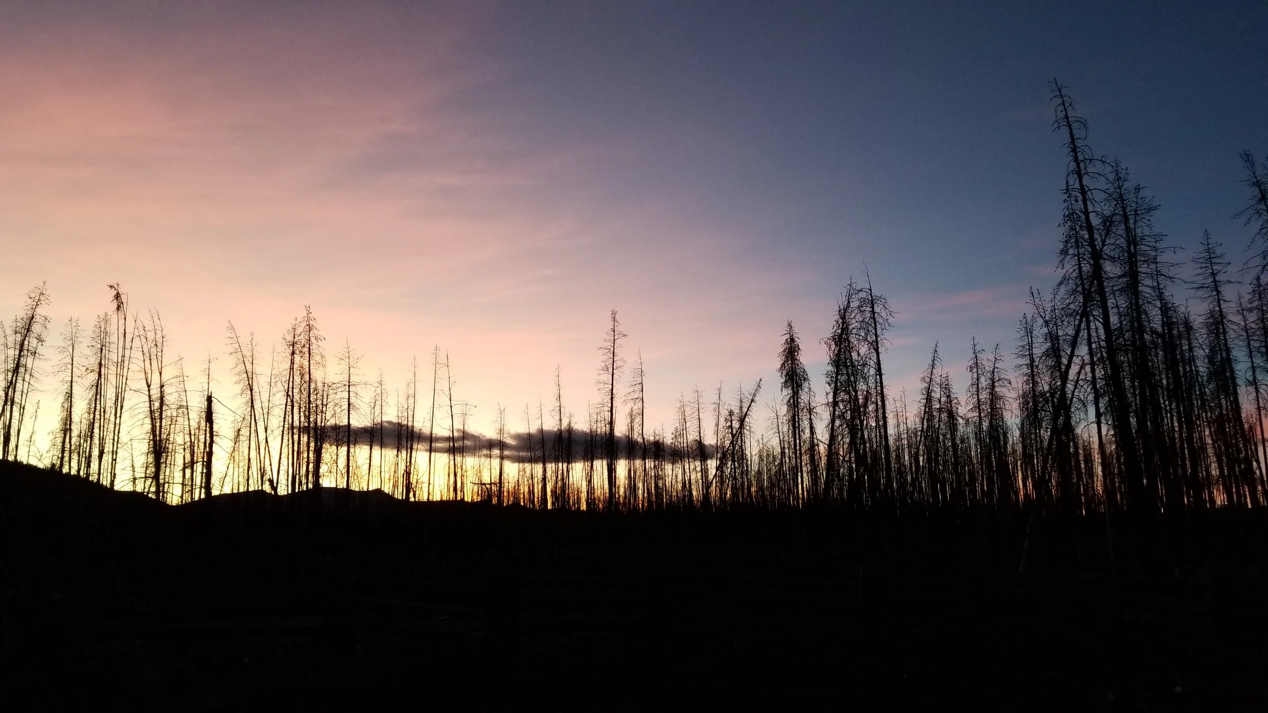

Shortly after dinner, I drove to the Park Creek Overlook, which looks out over a large clearing on the edge of a forest. Even though I was here mainly to stargaze and take astrophotography, I could see this being a terrific picnicking spot during the day, especially if wildlife came out to the clearing. Though there was a truck parked here, I didn’t see anyone at all. As far as I was concerned, I was all alone. I went about laying out my gear and setting up my tripod. At first, I set it up near the fence. Then I realized I wanted to get more of the sky in the photo, so I stepped on top of a nearby picnic table and set up the tripod on top of it, thereby improving the view. By now, it was past 7:30 p.m. The sun had already set, and the sky was beginning to darken. As I waited for night to come, I busied myself by taking photos of my surroundings and wondering whether bears, mountain lions, or wolves would get curious about me and get too close. The sight of the forest becoming progressively ominous under darkness unsettled me, reminding of how the forest looked in the 2016 film The Witch. The cold was sinking in as well, sending shivers up my arms.


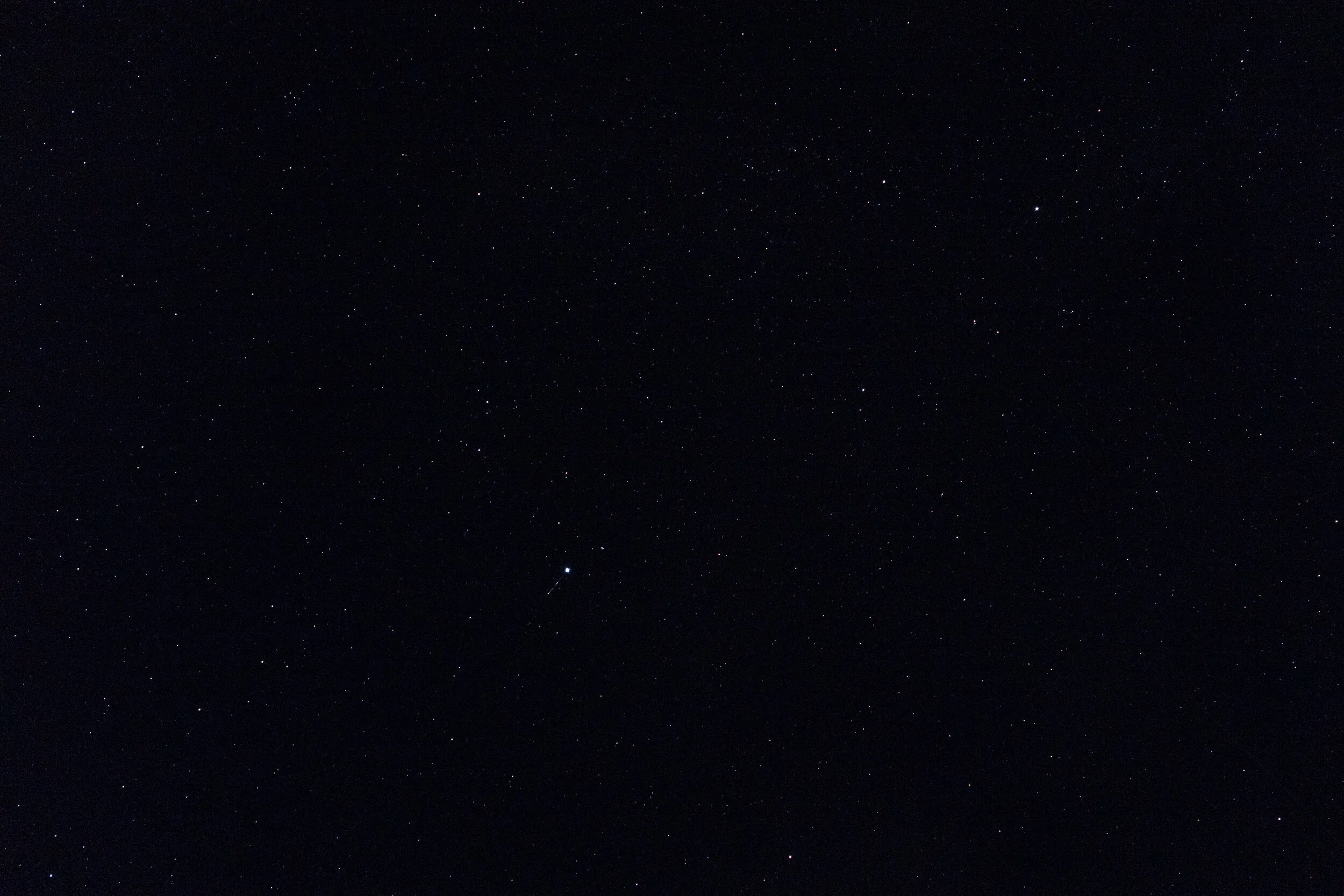

At long last, night fell, and my worries dissipated as the stars began to appear amidst the clear sky. This part of Idaho is a must-visit for avid stargazers; at one point, while I had my head down fiddling with my camera and phone settings for astrophotography, the Milky Way came into view, and it completely took my breath away when I saw it. As the minutes slipped by, the sky became an ocean of stars, and the sights made me just stop what I was doing, crane my head back, and just stare for minutes on end. The silence and solitude enhanced this experience all the more, and I got annoyed whenever cars passed by on the nearby road. It was, without a doubt, one of the most beautiful things I had ever seen. I ended up staying here for nearly two hours, and if I didn’t have to leave the following morning, I would have been there long past midnight. I ruefully took one final look at the heavens above before loading everything back into my car and returning to Stanley.
At the cabin, I browsed through the photos I took and saw that they didn’t come close to capturing the sheer magnificence of what I had just seen. Fortunately, this couldn’t bring me down from my high; this experience would forever be etched in my memories. I went to bed for my last night here in good spirits.
Day Four: Departure

The Triangle C Cabins office didn’t open until mid-morning, but they had a drop box where guests wanting to check out early can leave their keys. I dropped my key in there, and soon I was taking my last looks at Stanley as I left this lovely town just past 8:00 a.m.


After Stanley disappeared in my rearview mirror, I noticed an odd discoloration in the sky, but I couldn’t get a good look with the forest blocking my view. Once the forest opened up to the fields, I pulled over to the side of Highway 75 and rolled down the window. Sure enough, there was dark smoke rising from what looked like two places in the forest, clear evidence that there was a fire. I distinctly remembered seeing the Smokey Bear signs indicating the lack of forest fires lately over the course of my stay here, and I feared the worst. I debated whether to drop by the Stanley Ranger Station and voice my concern, but I already knew that the station was not open yet. I also reasoned that if I was seeing this, the rangers certainly had and most likely were already taking care of the fires. I drove on, and to my delight, in the fields I saw three antelope that I took a quick photo of.

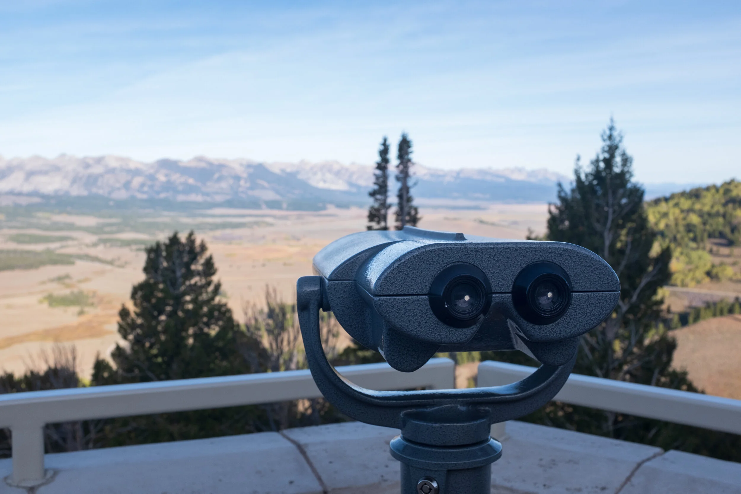
As Highway 75 went up into the mountains, I pulled over at Galena Summit Overlook, which was about 30 miles south of Stanley. From here, I got a clear view of the mountain range that stood tall above Stanley as well as the fields that I had driven through. I snapped several photos and looked at the mountains with a telescope, thinking back to everything I had experienced during my stay here. I turned to head back to my car, and to my great surprise, there stood Kristen and Mark from my hike! They recognized me too, and we chatted briefly about we had done yesterday. I asked them if they had seen the smoke from the fires, and they had. Mark said it wasn’t anything to worry about, as it as a prescribed burn, a controlled fire set intentionally by the rangers for forest management purposes. I breathed a sigh of relief upon hearing that. They too were leaving, and they were driving south to Twin Falls (the same direction as me) before making their way to Boise. We exchanged one last farewell, and they were off. I followed soon after.
I enjoyed the passing scenery as I left the Sawtooth National Forest. I made one last stop at the Sawtooth NRA - North Fork Visitor Center, partly to use the restroom and partly to ask the ranger there some questions. Mark was right about the prescribed burn. The antelope were actually called pronghorn, though the ranger said they also referred to them as sheep. Intrigued by these answers, I made note of them and thanked her before returning to the road, now racing against time to reach south Utah.
I came to the Sawtooth National Recreation Area expecting my trip to follow the itinerary I planned out. As I found out with my attempted hike, my canoeing attempt, and my astrophotography attempt (to name a few), not everything went according to plan, and what I experienced humbled me greatly. And yet, I left with nothing but great memories and a very satisfied heart.
I also didn’t eat a single potato during my time in Idaho, so take that, friends who joked about me coming here just to eat potatoes!